The Forestry Commission already has a very detailed 65-page pdf documenting correct implementation of forestry signage, usage of pictograms and even construction of benches and other forestry amenities. We would not need to abide by these specifications as far as I'm aware as the project is only meant to run in conjunction with the commission. However, it's definitely worth looking into the legalities of signage within rural environments as I have very little knowledge on this point. The basic visual language within the document, however, could be very useful with regards to colours and pictograms used. This semiotics wouldn't be the main target of appropriation though as this would be more based on traditional signage, not so much the polished manifesto pictured below.


In the UK we have a very simplistic system for denoting footpaths which includes the thick arrows in a variety of colours depending on their intended uses. These will very rarely be found hand painted here and are well maintained by the government. However, in some rare or very old instances, you may find a hand-painted arrow.
Here are some common signs you're likely to come across while out walking and what they mean:
 Footpath
Applies in England and Wales. Open to walkers only, waymarked with a yellow arrow.
 Bridleway
Applies in England and Wales. Open to walkers, horse-riders and cyclists, waymarked with a blue arrow.
 Restricted byway
Applies in England and Wales. Open to walkers, cyclists, horse-riders and horse-drawn vehicles, waymarked with a plum coloured arrow.
 Byway open to all traffic (BOAT)
Applies in England and Wales. Open to walkers, cyclists, horse-riders, horse-drawn vehicles and motor vehicles, waymarked with a red arrow.
 National Trails
Identifies 15 long distance routes in England and Wales. All are open for walking and some trails are also suitable for cyclists, horse-riders and people with limited mobility.
 Scotland's Great Trails
Identifies 26 long distance routes in Scotland. With the exception of the Great Glen Canoe Trail, all are open for walking and some trails are also suitable for cyclists, horse-riders and people with limited mobility.
 Open Access land
Just over a million hectares of mountain, moorland, heathland, down land, common land and public-owned woodland in England and Wales is available to people to walk, run, explore, climb and watch wildlife, without having to stay on paths.
 Negative access symbol
May be used to mark the end of area-wide access although other access rights may exist, for example, public rights of way.
 Home Zones
Home Zones – where roads and streets have been physically altered into more community-friendly spaces – give equal priority to drivers and people on foot or on bikes, with traffic-calming measures, very low traffic speeds and clear signs to alert and remind drivers to act with greater care.
 Quiet Lanes
Local authorities can designate roads as Quiet Lanes to make them safer and more attractive to walkers, cyclists and horse riders. Quiet lanes are usually minor rural roads connecting local villages and communities – and often footpaths and bridleways – where drivers are expected to adhere to lower speed limits.
G.R.
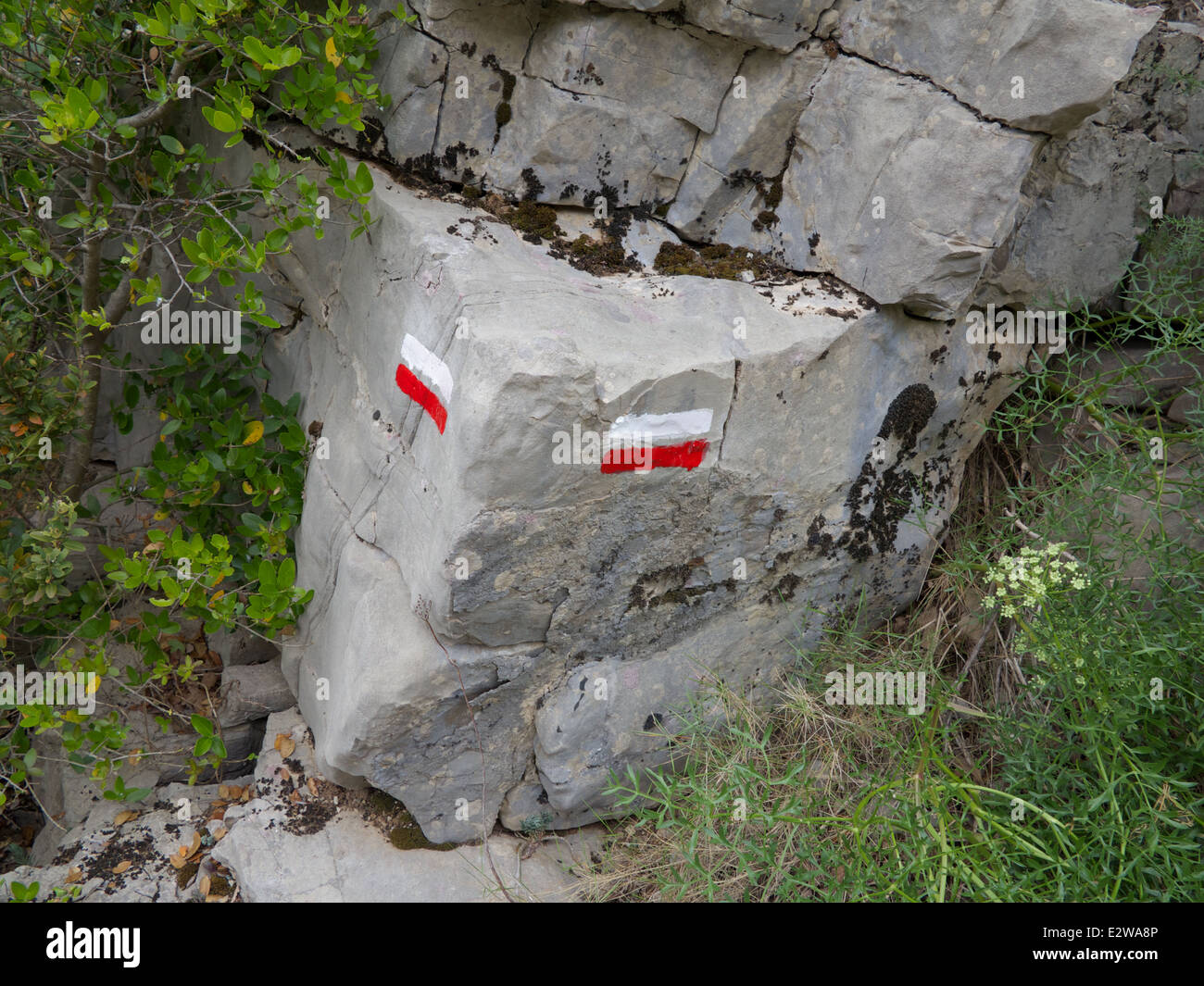
This is not the case on GR trails in Europe, as these trails are far more widespread so are often if not always hand painted. GR stands for Grande Randonnée (French), Grote Routepaden or Lange-afstand-wandelpaden (Dutch), Grande Rota (Portuguese) or Gran Recorrido (Spanish) and is a network of long-distance footpaths in Europe, mostly in France, Belgium, the Netherlands and Spain. The trails in France alone cover approximately 60,000 kilometres (37,000 mi). Trails are blazed with characteristic marks consisting of a white stripe above a red stripe. These appear regularly along the route, especially at places like forks or crossroads.
These GR markings are very visually inspiring due to their unique nature yet uniformity across thousands of miles of countryside, an internationally recognised visual language. They are made up of three main semiotics that not only indicate the correct route but also at times show when a wrong turn has been taken or a change of general direction is needed


Each path will also have a corresponding code that will be used in areas that present a chance of confusion.

Czech Republic
In other European countries, different traditions have been upheld and a variety of different semiotic approaches can be taken depending on the footpath. The examples below all come from the Czech Republic where different mountain ranges or intended uses will merit different types of sign. The blue and white left arrow is for walkers, whereas the large metal letters with arrows incorporated denote directions to specific locations such as Rokytnice nad Jizerou and the Dvoračky hostel.


No comments:
Post a Comment